


All About Political Maps
(2019)
Nonfiction
eBook
Details
PUBLISHED
[United States] : Gareth Stevens Publishing LLLP, 2019
Made available through hoopla
Made available through hoopla
DESCRIPTION
1 online resource (24 pages)
ISBN/ISSN
9781538230589 MWT18157192, 1538230585 18157192
LANGUAGE
English
NOTES
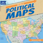
Which state is south of Maryland and north of North Carolina? How many states border California? How many countries are there in South America? As students read this book, they'll gain a better understanding of the locations of countries of the world. Using a map legend, they'll identify state and country capitals and other cities. They'll see how various landforms create natural borders. After comparing political maps of the United States at different times, students will be able to explain how the country grew. An activity concludes the book to help readers apply what they've learned
Mode of access: World Wide Web